For immediate release

HCSS Aerial Drone Software Increases Functionality; Adds Integration With HCSS HeavyJob Project Management
Sugar Land, Texas, Aug. 10, 2021 —HCSS, a leading provider of innovative solutions that help heavy civil businesses streamline operations, announces powerful new features for HCSS Aerial, a drone-based data analytics platform. This is the eighth upgrade since the introduction of the software and includes improvements with calculations and measurements, annotation and designs, and navigation. New features optimize Tablet performance and improve user experience with the mobile device.
"Customers have asked us to allow HCSS Aerial measurements and quantities data be integrated with HCSS HeavyJob Project Management and Job Cost solution," said J.P. Giometti, Vice President, Global Strategy and Corporate Development, HCSS. "We are Beta testing this integration and gathering feedback from clients before introduction. By integrating with HeavyJob, clients will be able to keep their jobs and budget on track with less expensive yet more accurate drone mapping."
"We recently switched over from a competitor and are elated with how things are going," said Grant Heaster, Project Manager/Estimator, Helms & Sons. "The ability to integrate the data into HeavyJob will help us track quantities more efficiently than before! Also, the quick turnaround time from upload to having the model processed is a huge time and money saver."
Features in the new update include:
- Create measurements and analytics from design items, saving time, whether users are running calculations to compare design to the as-built for quality assurance or checking bills from subcontractors. Simultaneously, eliminate any errors that might occur from manual drawing areas or lines.
- Quickly import images into HCSS Aerial to create a new annotation. The platform pins the annotation automatically, depending on the image's GPS position. Users inspecting a site on a tablet can effortlessly import the photographs while on the go.
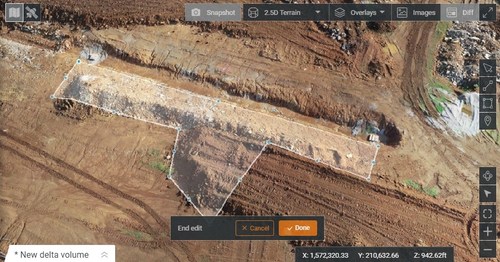
- Easier drawing or lines and polygons for measurements and analytics. Users can now make edits and adjust points in lines and polygons without starting any calculations. After editing is complete, simply click "Done" to recalculate measurements and analytics.
- Upload design files and notes before the first flight or while the flight is still being processed. This allows better collaboration with team members on the jobsite.
- A "Go to Coordinates" navigation tool can change a map display to a specific point by entering coordinates.
- Measurement details on top for tablets optimizes the small screen and allows users to choose between side navigation and a top-mounted calculation detail box.
If you'd like to see a demonstration of this functionality, please visit https://www.hcss.com/products/construction-drone-software/. Those investigating HCSS Aerial can quickly upload past drone flight photographs into an HCSS Aerial trial to understands its capabilities and potential, even if using another drone software or not.
About HCSS
Since 1986, HCSS has been developing software to help construction companies streamline their operations. Today, we are recognized as a pioneer and trusted leader in estimating, operations, and fleet software, serving thousands of construction companies across the nation. Visit www.hcss.com to learn more.
XXX

